http://www.weather.gov/riw/
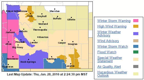
The National Weather Service in Riverton has issued a Winter Weather Advisory for Rock Springs, Green River, Flaming Gorge, and East Sweetwater County.
The advisory takes effect at 5 p.m. on Friday and will expire at 5 p.m. Saturday unless otherwise stated by the National Weather Service.
Light snow is expected Friday afternoon and will become heavier by Saturday morning. The most snow is expected Saturday morning/Saturday afternoon.
Snowfall between two and four inches is expected with winds between 15 and 25 mph and even stronger gusts.
Travel conditions are expected to be difficult on Saturday.
Below is the Winter Weather Advisory issued by the National Weather Service:
THE NATIONAL WEATHER SERVICE IN RIVERTON HAS ISSUED A WINTER WEATHER ADVISORY FOR SNOW AND BLOWING SNOW…WHICH IS IN EFFECT FROM 5 PM FRIDAY TO 5 PM MST SATURDAY.
* TIMING…LIGHT SNOW FRIDAY AFTERNOON WILL BECOME HEAVIER BY
SATURDAY MORNING…LASTING THROUGH THE DAY SATURDAY. THE
HEAVIEST SNOW IS EXPECTED SATURDAY MORNING INTO SATURDAY
AFTERNOON.
* SNOWFALL AMOUNTS…2 TO 4 INCHES.
* WINDS…SOUTHWEST BECOMING WEST AND INCREASING TO 15 TO 25 MPH
WITH HIGHER GUSTS.
* IMPACTS…THE COMBINATION OF MODERATE TO HEAVY SNOW AND GUSTY
WINDS WILL MAKE TRAVEL CONDITIONS DIFFICULT SATURDAY MORNING TO
SATURDAY NIGHT.
PRECAUTIONARY/PREPAREDNESS ACTIONS…
A WINTER WEATHER ADVISORY FOR SNOW AND BLOWING SNOW MEANS THAT VISIBILITIES WILL BE LIMITED DUE TO A COMBINATION OF FALLING AND BLOWING SNOW. USE CAUTION WHEN TRAVELING… ESPECIALLY IN OPEN AREAS.